
ARV
10 Weeks | Fall 2023
Credits
ARV is an airship concept centered around supporting a 6 person team with the intent of analyzing disaster data on the fly.
Special thanks to the designers at TEAGUE for their guidance and feedback.
Airship Research Vessel
Time
Design By

Madi Fassiotto
Primary Focus: VR Concept Testing | Illustration
Secondary Focus: Research | Visualizations

Keith Forsyth
Primary Focus: Research | Spatial Design
Secondary Focus: Rhino Modeling | VR Visualization

Ray McVicker
Primary Focus: Collaboration | Visualizations
Secondary Focus: Synthesis | Illustration | CAD

Elise Batten
Primary Focus: CMF
Secondary Focus: Visualization | User Synthesis
Flooding impacts more people than any other environmental disaster.
source: BBC
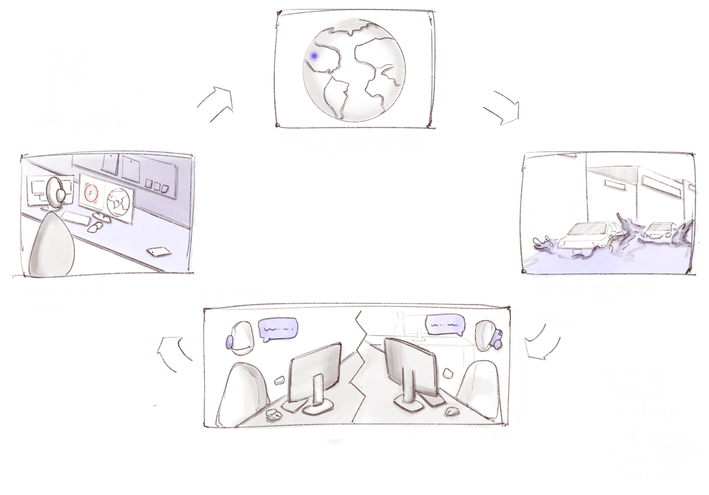
Current specialists are often far from disaster site, limiting situational awareness.
When a flood is predicted, the community and rescue teams are alerted.
Specialist work together, tho often from different locations and lack in person collaboration.
A holistic view of the scenario can be difficult when access is limited.
Improving early warning systems and disaster response
How might we enhance mitigation and response to flooding through advanced research and on-scene observation?
Before we could answer this, we needed to better understand the following:
-
Timeline
Organizations
Methods
-
Mapping Methods
Geographic Information Systems
Data Analysis
-
Emerging Technology
Strengths


Driven by research | Interviews

Tom - Land Surveyor + Humanitarian Aid Volunteer“Situational awareness is everything”
Liz - Whatcom Emergency Manager“It is a teamsport, it isn’t as much about what you know but who you know”
**need additional research methods: including other interviews, websites, articles, etc.
What was the takeaway/insight?
Gray - Contract Pilot for USGS + NOAA“I could see an airships innate qualities being well suited for data collection”


-
GIS mapping is a technology that allows users to create, analyze, visualize, and manage geographical data.
-
This article helped us gain an understanding of systemic issues associated with disasters as well as current challenges and perspectives.
“Factors that have inhibited the response to disasters in the past include, lack of a national-level plan policy, absence of an institutional framework at the center / state / district level, poor intersectoral coordination, lack of an early warning system, slow response from the relief agencies, lack of trained / dedicated search and rescue teams, and poor community empowerment.”
-Kalpana Srivastava written for the National Library of Medicine
-
OceanXplorer: Inside the world’s most advanced research vessel
New York Times: New Data Reveals Hidden Flood Risk Across America
NSSL: Severe Weather 101
CBO: FEMA’s Disaster Relief Fund

On the Job
Dedicated individuals supporting those in need.
-
Red Crescent, Red Cross, NOAA, USGS & more
-
Providing resources, medical assistance, search and rescue, infrastructure, and logistics.
-
Ground support personnel can be better informed and supported through enhanced communication with informed aerial observations.
Humanitarian Crisis Relief
How are different methods of relief addressed following a humanitarian crisis?

Data collection
A human-centric spatial design of an airship gondola which supports a dynamic team in understanding an affected area’s needs, resources, and allows them to better record insights to improve future response.
Data analysis
GIS (geographic information system) is a mapping software used to visualize and understand your data spatially.
Used in parallel with on-scene surveillance it allows for a high level of situational awareness.
Data application
Numerous applications for both humanitarian crisis mitigation + relief.
-
Timeline
Organizations
Methods
-
Mapping Methods
Geographic Information Systems
Data Analysis
-
Emerging Technology
Strengths


image: LTA Research
A human-centric spatial design of an airship gondola which supports a dynamic team in understanding an affected area’s needs, resources, and allows them to better record insights to improve future response.
Tethered to reality and future possibility
Lighter than Air Research is developing the next generation of airships focusing on advancing humanitarian aid.
The Pathfinder 1 is a proof of concept vessel LTA is currently developing. An airship designed for disaster response, leveraging its strengths of endurance, low airspeed, and hauling capacity, is a promising concept.

aIRSHIP rESEARCH VESSEL

image: LTA Research

Pilot
Needs:
no distractions
visibility
communication with crew

Data analysist
Needs:
monitor + workspace
reliable data
communication (internal)
Meet the team
Flight Crew
Co-Pilot
Needs:
no distractions
communication (internal + external)
crew coordination
Onboard Specialists
Logistics cordinator
Needs:
situational awareness
ease of communication (external)
rapid communication (internal)

Technician/ Deck Hand
Needs:
awareness of ship condition
access for maintenance
tools

Systems specialist
Needs:
visibility
access to sensors and cameras
communication (internal)
design criteria
-
Interior design supports connection between team and provides space for team work.
-
Real-time visibility of disaster benefits specialists’ understanding of disaster data and informs analysis.
-
Open sight lines throughout ship boost onboard communication. Multiple external transmission methods creates efficient communication with stakeholders on the ground.
-
In-person communication and situational awareness assists in prompt, informed decision-making.
-
Flexible work space enables specialized teams to adjust space to fit their needs.
Spatial design ideation
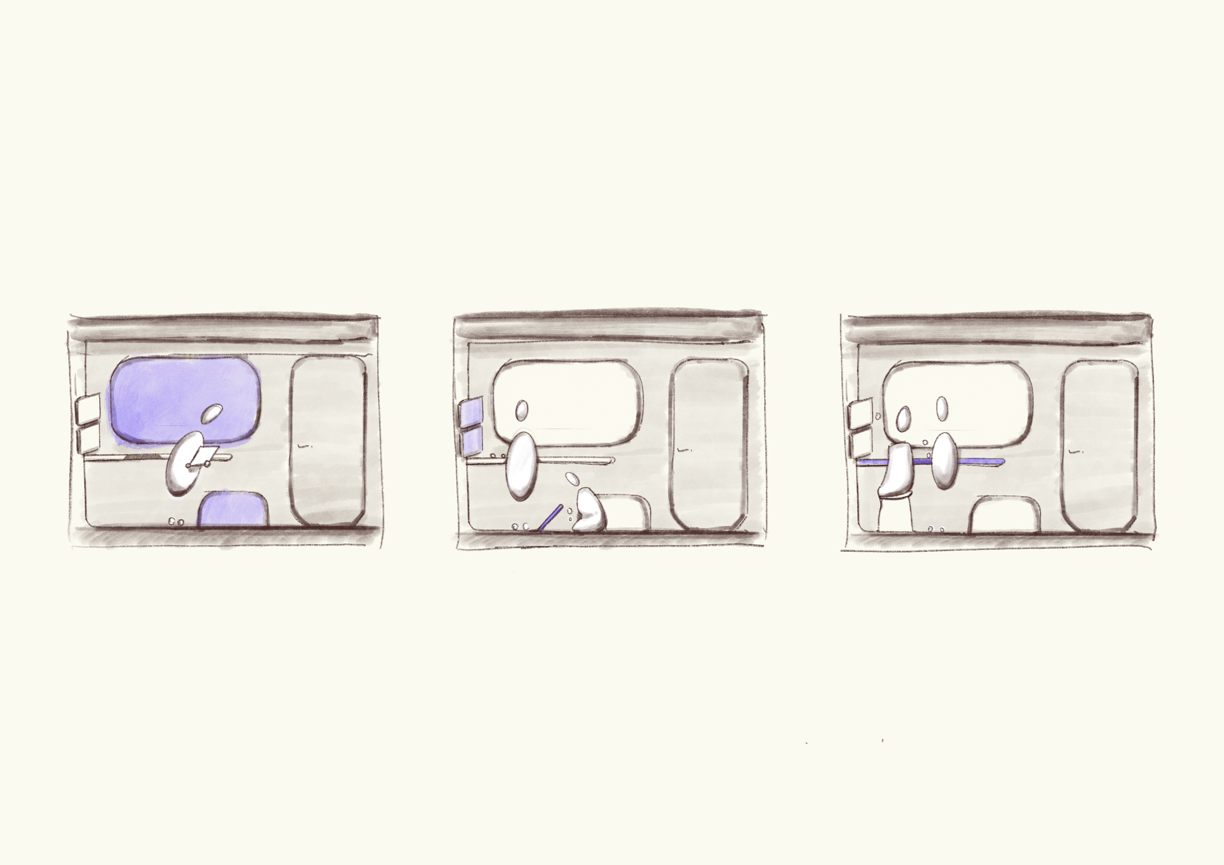
Exploring and addressing the needs of ARV’s team members through design matrixes, block floor planning and journey mapping.


VR Spatial Design Validation


To verify design decisions we used virtual reality in tandem with props to conduct spatial design, ergonomics, & human factor tests.

Test 01


Architectural Vision

Design Language

*call outs
Specialists workflow
Specialists spend most of their time in the work space collaborating.
Crew workflow
While the crew’s primary space is the cockpit they need access to the ships facilities.
Understanding Shared Space
Spatial design driven by specialists & crew needs.

Lighting vision
CMF Palette
tactility in Work
-
Smart devices used to facilitate work flow and communication.
-
Structural material highlighting adjustability on chairs.

Privacy in Living
-
A functional alternative to felt where soundproofing is needed.
-
Individual sleeping cubbies allow for privacy.

Comfort in Living +
-
Natural wood tones bring a warm quality to the living space.
-
Incorporation of textiles creates an inviting feel to the living spaces.
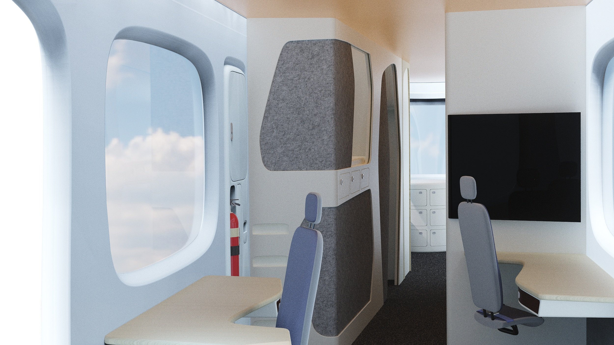
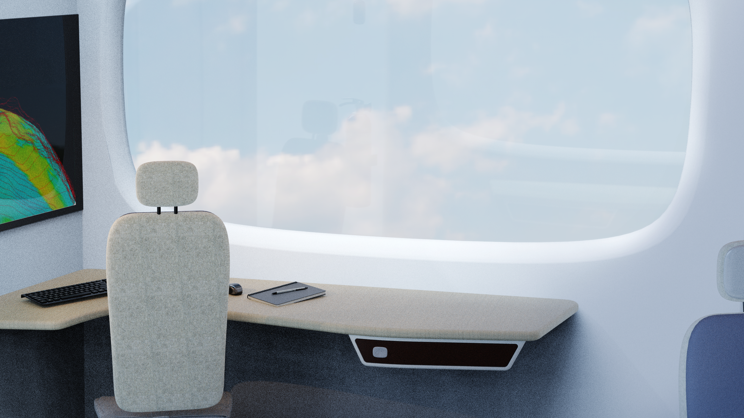
Work
Parameter work station layout allows easy access to external systems for maintenance crew
Personalized adjustability promote a collaborative and dynamic work environment
Situational awareness of disaster supports informed decisions

Living
Noise reduction screens provide a more private and serene space
Individualized storage for crews personal belongings
Workspace seating equipped for takeoff and landing
Living +
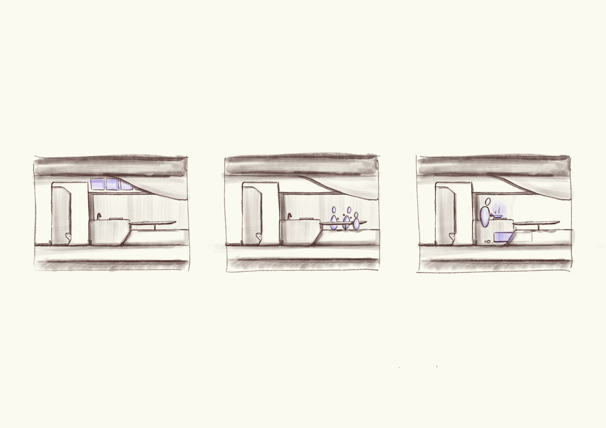
Shared dining space strengrthens onboard community
Induction stovetop an fresh food storage provides sense of home
Secured cook ware and readily accessible dry food storage


we did the thing…
check out my…
… how did we achieve our objectives…
